VisDrone Dataset
The VisDrone Dataset is a large-scale benchmark created by the AISKYEYE team at the Lab of Machine Learning and Data Mining, Tianjin University, China. It contains carefully annotated ground truth data for various computer vision tasks related to drone-based image and video analysis.
Watch: How to Train Ultralytics YOLO26 on the VisDrone Dataset | Aerial Detection | Complete Tutorial 🚀
VisDrone is composed of 288 video clips with 261,908 frames and 10,209 static images, captured by various drone-mounted cameras. The dataset covers a wide range of aspects, including location (14 different cities across China), environment (urban and rural), objects (pedestrians, vehicles, bicycles, etc.), and density (sparse and crowded scenes). The dataset was collected using various drone platforms under different scenarios and weather and lighting conditions. These frames are manually annotated with over 2.6 million bounding boxes of targets such as pedestrians, cars, bicycles, and tricycles. Attributes like scene visibility, object class, and occlusion are also provided for better data utilization.
Dataset Structure
The VisDrone dataset is organized into five main subsets, each focusing on a specific task:
- Task 1: Object detection in images
- Task 2: Object detection in videos
- Task 3: Single-object tracking
- Task 4: Multi-object tracking
- Task 5: Crowd counting
Applications
The VisDrone dataset is widely used for training and evaluating deep learning models in drone-based computer vision tasks such as object detection, object tracking, and crowd counting. The dataset's diverse set of sensor data, object annotations, and attributes make it a valuable resource for researchers and practitioners in the field of drone-based computer vision.
Dataset YAML
A YAML (Yet Another Markup Language) file is used to define the dataset configuration. It contains information about the dataset's paths, classes, and other relevant information. In the case of the Visdrone dataset, the VisDrone.yaml file is maintained at https://github.com/ultralytics/ultralytics/blob/main/ultralytics/cfg/datasets/VisDrone.yaml.
ultralytics/cfg/datasets/VisDrone.yaml
# Ultralytics 🚀 AGPL-3.0 License - https://ultralytics.com/license

# VisDrone2019-DET dataset https://github.com/VisDrone/VisDrone-Dataset by Tianjin University
# Documentation: https://docs.ultralytics.com/datasets/detect/visdrone/
# Example usage: yolo train data=VisDrone.yaml
# parent
# ├── ultralytics
# └── datasets
#     └── VisDrone ← downloads here (2.3 GB)

# Train/val/test sets as 1) dir: path/to/imgs, 2) file: path/to/imgs.txt, or 3) list: [path/to/imgs1, path/to/imgs2, ..]
path: VisDrone # dataset root dir
train: images/train # train images (relative to 'path') 6471 images
val: images/val # val images (relative to 'path') 548 images
test: images/test # test-dev images (optional) 1610 images

# Classes
names:
  0: pedestrian
  1: people
  2: bicycle
  3: car
  4: van
  5: truck
  6: tricycle
  7: awning-tricycle
  8: bus
  9: motor

# Download script/URL (optional) ---------------------------------------------------------------------------------------
download: |
  import os
  from pathlib import Path
  import shutil

  from ultralytics.utils.downloads import download
  from ultralytics.utils import ASSETS_URL, TQDM


  def visdrone2yolo(dir, split, source_name=None):
      """Convert VisDrone annotations to YOLO format with images/{split} and labels/{split} structure."""
      from PIL import Image

      source_dir = dir / (source_name or f"VisDrone2019-DET-{split}")
      images_dir = dir / "images" / split
      labels_dir = dir / "labels" / split
      labels_dir.mkdir(parents=True, exist_ok=True)

      # Move images to new structure
      if (source_images_dir := source_dir / "images").exists():
          images_dir.mkdir(parents=True, exist_ok=True)
          for img in source_images_dir.glob("*.jpg"):
              img.rename(images_dir / img.name)

      for f in TQDM((source_dir / "annotations").glob("*.txt"), desc=f"Converting {split}"):
          img_size = Image.open(images_dir / f.with_suffix(".jpg").name).size
          dw, dh = 1.0 / img_size[0], 1.0 / img_size[1]
          lines = []

          with open(f, encoding="utf-8") as file:
              for row in [x.split(",") for x in file.read().strip().splitlines()]:
                  if row[4] != "0":  # Skip ignored regions
                      x, y, w, h = map(int, row[:4])
                      cls = int(row[5]) - 1
                      # Convert to YOLO format
                      x_center, y_center = (x + w / 2) * dw, (y + h / 2) * dh
                      w_norm, h_norm = w * dw, h * dh
                      lines.append(f"{cls} {x_center:.6f} {y_center:.6f} {w_norm:.6f} {h_norm:.6f}\n")

          (labels_dir / f.name).write_text("".join(lines), encoding="utf-8")


  # Download (ignores test-challenge split)
  dir = Path(yaml["path"])  # dataset root dir
  urls = [
      f"{ASSETS_URL}/VisDrone2019-DET-train.zip",
      f"{ASSETS_URL}/VisDrone2019-DET-val.zip",
      f"{ASSETS_URL}/VisDrone2019-DET-test-dev.zip",
      # f"{ASSETS_URL}/VisDrone2019-DET-test-challenge.zip",
  ]
  download(urls, dir=dir, threads=4)

  # Convert
  splits = {"VisDrone2019-DET-train": "train", "VisDrone2019-DET-val": "val", "VisDrone2019-DET-test-dev": "test"}
  for folder, split in splits.items():
      visdrone2yolo(dir, split, folder)  # convert VisDrone annotations to YOLO labels
      shutil.rmtree(dir / folder)  # cleanup original directory
Usage
To train a YOLO26n model on the VisDrone dataset for 100 epochs with an image size of 640, you can use the following code snippets. For a comprehensive list of available arguments, refer to the model Training page.
Train Example
from ultralytics import YOLO

# Load a model
model = YOLO("yolo26n.pt")  # load a pretrained model (recommended for training)

# Train the model
results = model.train(data="VisDrone.yaml", epochs=100, imgsz=640)
# Start training from a pretrained *.pt model
yolo detect train data=VisDrone.yaml model=yolo26n.pt epochs=100 imgsz=640
Sample Data and Annotations
The VisDrone dataset contains a diverse set of images and videos captured by drone-mounted cameras. Here are some examples of data from the dataset, along with their corresponding annotations:
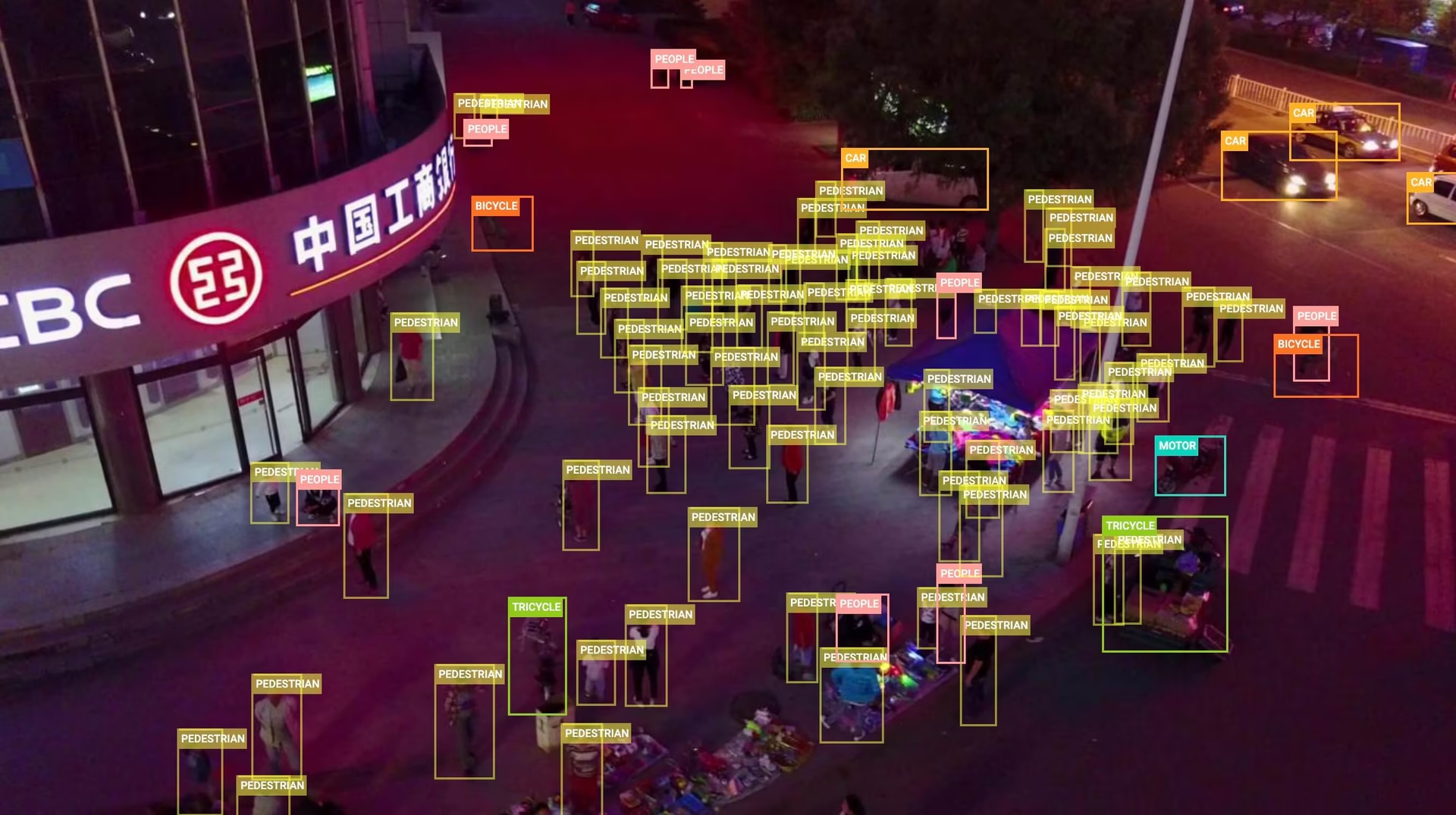
- Task 1: Object detection in images - This image demonstrates an example of object detection in images, where objects are annotated with bounding boxes. The dataset provides a wide variety of images taken from different locations, environments, and densities to facilitate the development of models for this task.
The example showcases the variety and complexity of the data in the VisDrone dataset and highlights the importance of high-quality sensor data for drone-based computer vision tasks.
Citations and Acknowledgments
If you use the VisDrone dataset in your research or development work, please cite the following paper:
@ARTICLE{9573394,
  author={Zhu, Pengfei and Wen, Longyin and Du, Dawei and Bian, Xiao and Fan, Heng and Hu, Qinghua and Ling, Haibin},
  journal={IEEE Transactions on Pattern Analysis and Machine Intelligence},
  title={Detection and Tracking Meet Drones Challenge},
  year={2021},
  volume={},
  number={},
  pages={1-1},
  doi={10.1109/TPAMI.2021.3119563}}
We would like to acknowledge the AISKYEYE team at the Lab of Machine Learning and Data Mining, Tianjin University, China, for creating and maintaining the VisDrone dataset as a valuable resource for the drone-based computer vision research community. For more information about the VisDrone dataset and its creators, visit the VisDrone Dataset GitHub repository.
FAQ
What is the VisDrone Dataset and what are its key features?
The VisDrone Dataset is a large-scale benchmark created by the AISKYEYE team at Tianjin University, China. It is designed for various computer vision tasks related to drone-based image and video analysis. Key features include:
- Composition: 288 video clips with 261,908 frames and 10,209 static images.
- Annotations: Over 2.6 million bounding boxes for objects like pedestrians, cars, bicycles, and tricycles.
- Diversity: Collected across 14 cities, in urban and rural settings, under different weather and lighting conditions.
- Tasks: Split into five main tasks—object detection in images and videos, single-object and multi-object tracking, and crowd counting.
How can I use the VisDrone Dataset to train a YOLO26 model with Ultralytics?
To train a YOLO26 model on the VisDrone dataset for 100 epochs with an image size of 640, you can follow these steps:
Train Example
from ultralytics import YOLO

# Load a pretrained model
model = YOLO("yolo26n.pt")

# Train the model
results = model.train(data="VisDrone.yaml", epochs=100, imgsz=640)
# Start training from a pretrained *.pt model
yolo detect train data=VisDrone.yaml model=yolo26n.pt epochs=100 imgsz=640
For additional configuration options, please refer to the model Training page.
What are the main subsets of the VisDrone dataset and their applications?
The VisDrone dataset is divided into five main subsets, each tailored for a specific computer vision task:
- Task 1: Object detection in images.
- Task 2: Object detection in videos.
- Task 3: Single-object tracking.
- Task 4: Multi-object tracking.
- Task 5: Crowd counting.
These subsets are widely used for training and evaluating deep learning models in drone-based applications such as surveillance, traffic monitoring, and public safety.
Where can I find the configuration file for the VisDrone dataset in Ultralytics?
The configuration file for the VisDrone dataset, VisDrone.yaml, can be found in the Ultralytics repository at the following link:
VisDrone.yaml.
How can I cite the VisDrone dataset if I use it in my research?
If you use the VisDrone dataset in your research or development work, please cite the following paper:
@ARTICLE{9573394,
  author={Zhu, Pengfei and Wen, Longyin and Du, Dawei and Bian, Xiao and Fan, Heng and Hu, Qinghua and Ling, Haibin},
  journal={IEEE Transactions on Pattern Analysis and Machine Intelligence},
  title={Detection and Tracking Meet Drones Challenge},
  year={2021},
  volume={},
  number={},
  pages={1-1},
  doi={10.1109/TPAMI.2021.3119563}
}


