Link to this sectionxView データセット#
xView データセットは、物体検出のための公開されている衛星画像ベンチマークの中でも最大級のものです。0.3m解像度のWorldView-3衛星画像1,400km²以上にわたり、60クラスの100万件以上の物体インスタンスがバウンディングボックスでアノテーションされています。これは米国国家地理空間情報局 (NGA) によるDIUx xView 2018 Challengeのためにリリースされたもので、約20.7GBの手動ダウンロードが必要です。
このデータセットは、以下の4つのコンピュータビジョンのフロンティアを推進するために作成されました。
- 検出に必要な最小解像度の低減。
- 学習効率の向上。
- より多くのオブジェクトクラスの発見を可能にする。
- 微細なクラスの検出精度向上。
COCOのようなベンチマークに基づき、xViewは地上の写真よりも物体が遥かに小さく密集している航空画像(俯瞰画像)を対象としています。
xViewデータセットは自動的にはダウンロードされません。DIUx xView 2018 Challengeウェブサイトに登録してtrain_images.zip (~15 GB)、train_labels.zip、val_images.zip (~5 GB) をダウンロードし、datasets/xView/ 配下に解凍して以下の構成になるように配置してください。
datasets/xView/
├── train_images/          # 847 TIF satellite images
├── val_images/            # 282 TIF images (no public labels)
└── xView_train.geojson    # bounding-box annotations
最初のトレーニング実行時に、UltralyticsはGeoJSONアノテーションをYOLO形式に変換し、ラベル付けされた画像を自動的に約90:10の割合でトレーニングセットと検証セットに分割します。手動での変換は不要です。
Link to this section主な特徴#
- きめ細かいクラス: 航空機、車両、鉄道車両、船舶、建設機械、建物など、小型で希少かつ視覚的に類似した物体を含む60の物体クラス。
- 高解像度: WorldView-3衛星から収集された0.3mの地上解像度。
- 高密度なアノテーション: 1,400km²以上の画像にわたる100万以上の物体インスタンスが、すべて水平バウンディングボックスでラベル付けされています。
- 自動変換: Ultralyticsのダウンロードスクリプトが、元のGeoJSONラベルをYOLO形式に変換し、初回使用時にトレーニング/検証の分割を生成します。
Link to this sectionデータセットの構造#
xViewの画像はTIF形式の大きな衛星シーンであり、公開されているラベルが含まれるのは847枚のトレーニング画像のみです(282枚のチャレンジ検証セットにはラベルがありません)。そのため、UltralyticsのxView.yaml設定ファイルは、初回使用時にラベル付き画像を自動的に分割します。
| 分割 | 画像 | 説明 |
|---|---|---|
| トレーニング | 847枚の約90% | 初回実行時に生成されるautosplit_train.txtにリストされたラベル付き画像 |
| バリデーション | 847枚の約10% | autosplit_val.txt にリストされているラベル付き画像で、評価に使用されます |
60クラスには、固定翼機、貨物機、小型車、バス、機関車、船舶、ショベルカー、建物、格納庫、貯蔵タンクといった詳細なカテゴリが含まれており、完全なリストは以下のデータセットYAMLに記載されています。変換中、元のチャレンジクラスID(11~94)は0~59の連続したインデックスに再マッピングされます。
Link to this sectionアプリケーション#
xViewのきめ細かいクラスと高解像度の俯瞰視点は、ディープラーニングモデルをリモートセンシングでトレーニングおよび評価するための標準的なベンチマークとなっています。一般的なアプリケーションには以下が含まれます。
- 軍事・防衛偵察
- 都市計画および開発
- 環境モニタリング
- 災害対応および評価
- インフラのマッピングと管理
その他の俯瞰画像ベンチマークについては、ドローンに特化したVisDroneデータセットや、回転ボックス対応のDOTA-v2データセットを参照してください。
Link to this sectionデータセット YAML#
xView.yamlファイルは、データセットパス、60のクラス名、GeoJSONアノテーションを変換して自動分割を生成するダウンロードスクリプトなど、データセット設定を定義します。これはUltralyticsリポジトリ(https://github.com/ultralytics/ultralytics/blob/main/ultralytics/cfg/datasets/xView.yaml)で管理されています。
# Ultralytics 🚀 AGPL-3.0 License - https://ultralytics.com/license

# DIUx xView 2018 Challenge dataset https://challenge.xviewdataset.org by U.S. National Geospatial-Intelligence Agency (NGA)
# --------  Download and extract data manually to `datasets/xView` before running the train command.  --------
# Documentation: https://docs.ultralytics.com/datasets/detect/xview
# Example usage: yolo train data=xView.yaml
# parent
# ├── ultralytics
# └── datasets
#     └── xView ← downloads here (20.7 GB)

# Train/val/test sets as 1) dir: path/to/imgs, 2) file: path/to/imgs.txt, or 3) list: [path/to/imgs1, path/to/imgs2, ..]
path: xView # dataset root dir
train: images/autosplit_train.txt # train images (relative to 'path') 90% of 847 train images
val: images/autosplit_val.txt # val images (relative to 'path') 10% of 847 train images

# Classes
names:
  0: Fixed-wing Aircraft
  1: Small Aircraft
  2: Cargo Plane
  3: Helicopter
  4: Passenger Vehicle
  5: Small Car
  6: Bus
  7: Pickup Truck
  8: Utility Truck
  9: Truck
  10: Cargo Truck
  11: Truck w/Box
  12: Truck Tractor
  13: Trailer
  14: Truck w/Flatbed
  15: Truck w/Liquid
  16: Crane Truck
  17: Railway Vehicle
  18: Passenger Car
  19: Cargo Car
  20: Flat Car
  21: Tank car
  22: Locomotive
  23: Maritime Vessel
  24: Motorboat
  25: Sailboat
  26: Tugboat
  27: Barge
  28: Fishing Vessel
  29: Ferry
  30: Yacht
  31: Container Ship
  32: Oil Tanker
  33: Engineering Vehicle
  34: Tower crane
  35: Container Crane
  36: Reach Stacker
  37: Straddle Carrier
  38: Mobile Crane
  39: Dump Truck
  40: Haul Truck
  41: Scraper/Tractor
  42: Front loader/Bulldozer
  43: Excavator
  44: Cement Mixer
  45: Ground Grader
  46: Hut/Tent
  47: Shed
  48: Building
  49: Aircraft Hangar
  50: Damaged Building
  51: Facility
  52: Construction Site
  53: Vehicle Lot
  54: Helipad
  55: Storage Tank
  56: Shipping container lot
  57: Shipping Container
  58: Pylon
  59: Tower

# Download script/URL (optional) ---------------------------------------------------------------------------------------
download: |
  import json
  from pathlib import Path
  import shutil

  import numpy as np
  from PIL import Image

  from ultralytics.utils import TQDM
  from ultralytics.data.split import autosplit
  from ultralytics.utils.ops import xyxy2xywhn

  def convert_labels(fname=Path("xView/xView_train.geojson")):
      """Convert xView GeoJSON labels to YOLO format (classes 0-59) and save them as text files."""
      path = fname.parent
      with open(fname, encoding="utf-8") as f:
          print(f"Loading {fname}...")
          data = json.load(f)

      # Make dirs
      labels = path / "labels" / "train"
      shutil.rmtree(labels, ignore_errors=True)
      labels.mkdir(parents=True, exist_ok=True)

      # xView classes 11-94 to 0-59
      xview_class2index = [-1, -1, -1, -1, -1, -1, -1, -1, -1, -1, -1, 0, 1, 2, -1, 3, -1, 4, 5, 6, 7, 8, -1, 9, 10, 11,
                           12, 13, 14, 15, -1, -1, 16, 17, 18, 19, 20, 21, 22, -1, 23, 24, 25, -1, 26, 27, -1, 28, -1,
                           29, 30, 31, 32, 33, 34, 35, 36, 37, -1, 38, 39, 40, 41, 42, 43, 44, 45, -1, -1, -1, -1, 46,
                           47, 48, 49, -1, 50, 51, -1, 52, -1, -1, -1, 53, 54, -1, 55, -1, -1, 56, -1, 57, -1, 58, 59]

      shapes = {}
      for feature in TQDM(data["features"], desc=f"Converting {fname}"):
          p = feature["properties"]
          if p["bounds_imcoords"]:
              image_id = p["image_id"]
              image_file = path / "train_images" / image_id
              if image_file.exists():  # 1395.tif missing
                  try:
                      box = np.array([int(num) for num in p["bounds_imcoords"].split(",")])
                      assert box.shape[0] == 4, f"incorrect box shape {box.shape[0]}"
                      cls = p["type_id"]
                      cls = xview_class2index[int(cls)]  # xView class to 0-59
                      assert 59 >= cls >= 0, f"incorrect class index {cls}"

                      # Write YOLO label
                      if image_id not in shapes:
                          shapes[image_id] = Image.open(image_file).size
                      box = xyxy2xywhn(box[None].astype(float), w=shapes[image_id][0], h=shapes[image_id][1], clip=True)
                      with open((labels / image_id).with_suffix(".txt"), "a", encoding="utf-8") as f:
                          f.write(f"{cls} {' '.join(f'{x:.6f}' for x in box[0])}\n")  # write label.txt
                  except Exception as e:
                      print(f"WARNING: skipping one label for {image_file}: {e}")

  # Download manually from https://challenge.xviewdataset.org
  dir = Path(yaml["path"])  # dataset root dir
  # urls = [
  #     "https://d307kc0mrhucc3.cloudfront.net/train_labels.zip",  # train labels
  #     "https://d307kc0mrhucc3.cloudfront.net/train_images.zip",  # 15G, 847 train images
  #     "https://d307kc0mrhucc3.cloudfront.net/val_images.zip",  # 5G, 282 val images (no labels)
  # ]
  # download(urls, dir=dir)

  # Convert labels
  convert_labels(dir / "xView_train.geojson")

  # Move images
  images = Path(dir / "images")
  images.mkdir(parents=True, exist_ok=True)
  Path(dir / "train_images").rename(dir / "images" / "train")
  Path(dir / "val_images").rename(dir / "images" / "val")

  # Split
  autosplit(dir / "images" / "train")
Link to this section使用方法#
トレーニングを実行するには、前述の手動ダウンロードデータをdatasets/xView/配下に解凍しておく必要があります。アノテーションの変換とトレーニング/検証の分割は、自動的に実行されます。
xView データセットを使用して画像サイズ640で100 エポックのモデルをトレーニングするには、以下のコードスニペットを使用できます。利用可能な引数の完全なリストについては、モデルのトレーニングページを参照してください。
from ultralytics import YOLO

# Load a model
model = YOLO("yolo26n.pt")  # load a pretrained model (recommended for training)

# Train the model
results = model.train(data="xView.yaml", epochs=100, imgsz=640)追加の衛星画像のラベル付けや、ブラウザ上でのxViewトレーニング実行管理を行うには、Ultralytics Platformをご利用ください。
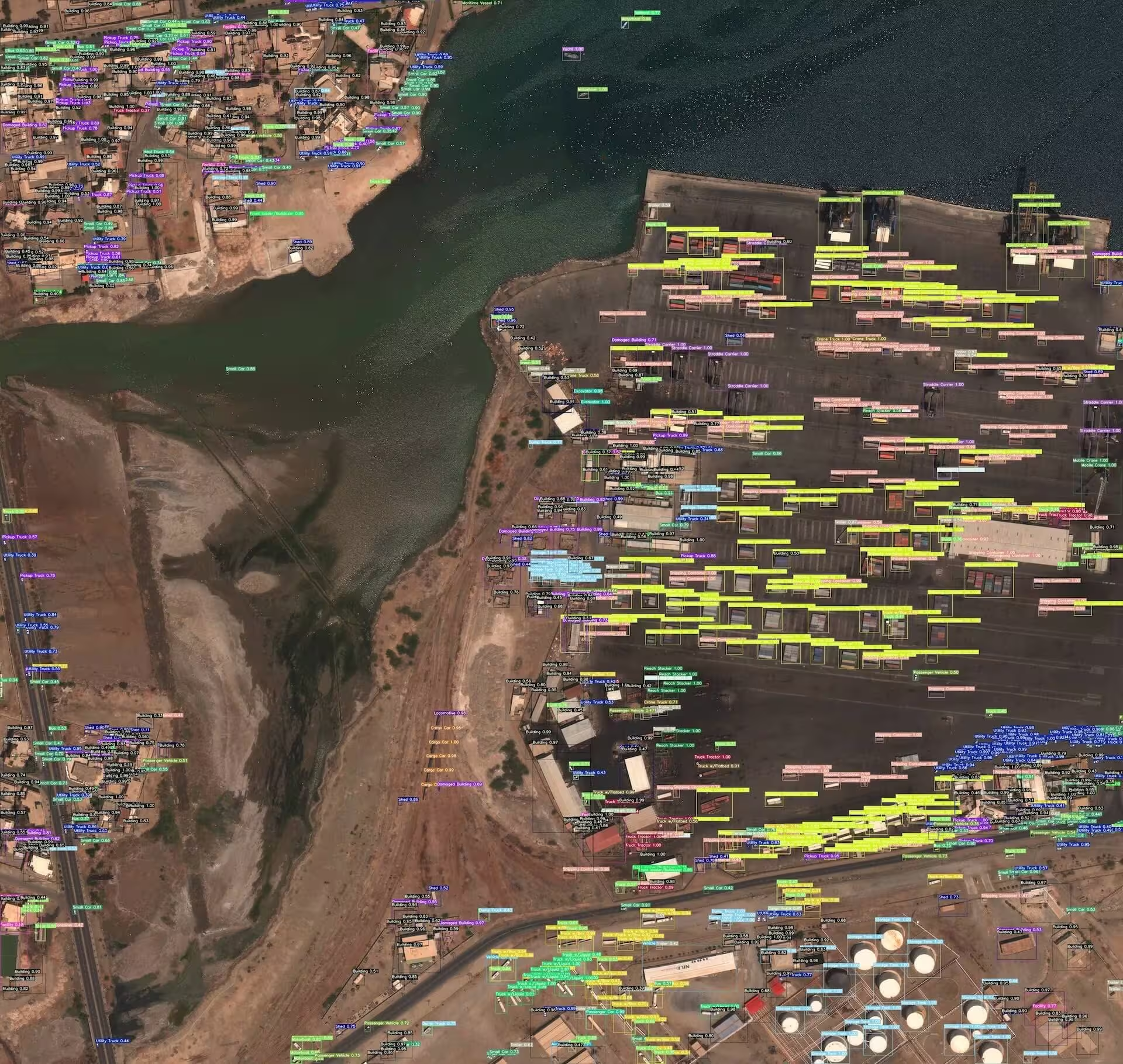
Link to this sectionサンプルデータとアノテーション#
以下のサンプルは典型的なxViewのシーンを示しています。車両や建物などの小さな物体がバウンディングボックスでアノテーションされた高解像度の俯瞰画像であり、衛星画像における物体検出がいかにきめ細かなローカリゼーションを必要とするかを物語っています。
Link to this section引用と謝辞#
研究や開発作業で xView データセットを使用する場合は、以下の論文を引用してください:
@misc{lam2018xview,
      title={xView: Objects in Context in Overhead Imagery},
      author={Darius Lam and Richard Kuzma and Kevin McGee and Samuel Dooley and Michael Laielli and Matthew Klaric and Yaroslav Bulatov and Brendan McCord},
      year={2018},
      eprint={1802.07856},
      archivePrefix={arXiv},
      primaryClass={cs.CV}
}
Defense Innovation Unit (DIU) およびxViewデータセットの作成者による、コンピュータビジョン研究コミュニティへの貴重な貢献に感謝いたします。詳細については、xViewデータセットのウェブサイトをご覧ください。
Link to this sectionよくある質問 (FAQ)#
Link to this sectionxView データセットとは何ですか?また、どのようにコンピュータビジョン研究に貢献しますか?#
xViewデータセットは、米国国家地理空間情報局がDIUx xView 2018 Challengeのためにリリースした衛星画像ベンチマークであり、0.3m解像度のWorldView-3画像において、60のきめ細かいクラスで100万件以上の物体インスタンスを提供します。これは、地上の写真よりも遥かに困難なターゲットである、俯瞰画像内の小さく希少で詳細な物体の検出に関する研究を支援します。
Link to this sectionxViewデータセットをダウンロードしてセットアップする方法は?#
xViewは手動ダウンロードが必要です。DIUx xView 2018 Challengeウェブサイトに登録し、train_images.zip (~15 GB)、train_labels.zip、val_images.zip (~5 GB) を合計約20.7 GBダウンロードし、ページ上部の警告に記載されているレイアウトに従ってdatasets/xView/配下に解凍してください。最初のトレーニング実行時に、Ultralyticsが自動的にGeoJSONアノテーションをYOLO形式に変換し、トレーニング/検証の分割を作成します。
Link to this sectionxViewには何枚の画像といくつのクラスがありますか?#
xViewには、0.3m解像度のWorldView-3衛星で撮影された、847枚のラベル付きトレーニング画像と、ラベルが公開されていない282枚の検証画像が含まれています。アノテーションは60クラスにわたる100万件以上の物体インスタンスをカバーしています。トレーニングラベルのみが公開されているため、UltralyticsのxView.yaml設定では、847枚のラベル付き画像をトレーニングセットと検証セットに約90:10の割合で分割します。詳細はデータセット構造を参照してください。
Link to this sectionxViewデータセットでYOLO26モデルをトレーニングする方法は?#
xView上で、画像サイズ640、100エポックでYOLO26nモデルをトレーニングします。
from ultralytics import YOLO

# Load a model
model = YOLO("yolo26n.pt")  # load a pretrained model (recommended for training)

# Train the model
results = model.train(data="xView.yaml", epochs=100, imgsz=640)詳細な引数と設定については、モデルのトレーニングページを参照してください。
Link to this section研究で xView データセットを引用するにはどうすればよいですか?#
論文「xView: Objects in Context in Overhead Imagery」(Lam et al., arXiv:1802.07856, 2018) を引用してください。完全なBibTeXエントリーは上記の引用と謝辞セクションにあります。