xView Dataset#
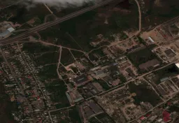
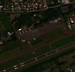
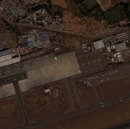
The xView dataset is one of the largest publicly available satellite-imagery benchmarks for object detection, providing over 1 million object instances across 60 classes annotated with bounding boxes in more than 1,400 km² of 0.3 m WorldView-3 imagery. It was released for the DIUx xView 2018 Challenge by the U.S. National Geospatial-Intelligence Agency (NGA) and requires a manual download of about 20.7 GB.
The dataset was created to push four computer vision frontiers:
- Reduce minimum resolution for detection.
- Improve learning efficiency.
- Enable discovery of more object classes.
- Improve detection of fine-grained classes.
Building on benchmarks like COCO, xView targets overhead imagery, where objects are far smaller and more densely packed than in ground-level photos.
The xView dataset is not downloaded automatically. Register at the DIUx xView 2018 Challenge website to download train_images.zip (~15 GB), train_labels.zip, and val_images.zip (~5 GB), then extract them under datasets/xView/ so that it contains:
datasets/xView/
├── train_images/          # 847 TIF satellite images
├── val_images/            # 282 TIF images (no public labels)
└── xView_train.geojson    # bounding-box annotations
On the first training run, Ultralytics converts the GeoJSON annotations to YOLO format and splits the labeled images roughly 90/10 into training and validation sets automatically — no manual conversion is needed.
Key Features#
- Fine-grained classes: 60 object classes spanning aircraft, vehicles, railway stock, maritime vessels, construction equipment, and buildings — many small, rare, and visually similar.
- High resolution: 0.3 m ground sample distance collected from WorldView-3 satellites.
- Dense annotation: over 1 million object instances across more than 1,400 km² of imagery, all labeled with horizontal bounding boxes.
- Automatic conversion: the Ultralytics download script converts the original GeoJSON labels to YOLO format and generates the train/val split on first use.
Dataset Structure#
xView images are large satellite scenes in TIF format, and only the 847 training images ship with public labels — the 282-image challenge validation set has none. The Ultralytics xView.yaml configuration therefore splits the labeled images automatically on first use:
| Split | Images | Description |
|---|---|---|
| Train | ~90% of 847 | Labeled images listed in autosplit_train.txt, generated on the first run |
| Validation | ~10% of 847 | Labeled images listed in autosplit_val.txt, used for evaluation |
The 60 classes cover fine-grained categories such as Fixed-wing Aircraft, Cargo Plane, Small Car, Bus, Locomotive, Maritime Vessel, Excavator, Building, Aircraft Hangar, and Storage Tank; the full list is in the Dataset YAML below. During conversion, the original challenge class IDs (11–94) are remapped to contiguous indices 0–59.
Applications#
xView's fine-grained classes and high-resolution overhead viewpoint make it a standard benchmark for training and evaluating deep learning models in remote sensing. Common applications include:
- Military and defense reconnaissance
- Urban planning and development
- Environmental monitoring
- Disaster response and assessment
- Infrastructure mapping and management
For other overhead-imagery benchmarks, see the drone-focused VisDrone dataset or the oriented-box DOTA-v2 dataset.
Dataset YAML#
The xView.yaml file defines the dataset configuration — the dataset paths, the 60 class names, and the download script that converts the GeoJSON annotations and generates the autosplit. It is maintained in the Ultralytics repository at https://github.com/ultralytics/ultralytics/blob/main/ultralytics/cfg/datasets/xView.yaml.
# Ultralytics 🚀 AGPL-3.0 License - https://ultralytics.com/license

# DIUx xView 2018 Challenge dataset https://challenge.xviewdataset.org by U.S. National Geospatial-Intelligence Agency (NGA)
# --------  Download and extract data manually to `datasets/xView` before running the train command.  --------
# Documentation: https://docs.ultralytics.com/datasets/detect/xview
# Example usage: yolo train data=xView.yaml
# parent
# ├── ultralytics
# └── datasets
#     └── xView ← downloads here (20.7 GB)

# Train/val/test sets as 1) dir: path/to/imgs, 2) file: path/to/imgs.txt, or 3) list: [path/to/imgs1, path/to/imgs2, ..]
path: xView # dataset root dir
train: images/autosplit_train.txt # train images (relative to 'path') 90% of 847 train images
val: images/autosplit_val.txt # val images (relative to 'path') 10% of 847 train images

# Classes
names:
  0: Fixed-wing Aircraft
  1: Small Aircraft
  2: Cargo Plane
  3: Helicopter
  4: Passenger Vehicle
  5: Small Car
  6: Bus
  7: Pickup Truck
  8: Utility Truck
  9: Truck
  10: Cargo Truck
  11: Truck w/Box
  12: Truck Tractor
  13: Trailer
  14: Truck w/Flatbed
  15: Truck w/Liquid
  16: Crane Truck
  17: Railway Vehicle
  18: Passenger Car
  19: Cargo Car
  20: Flat Car
  21: Tank car
  22: Locomotive
  23: Maritime Vessel
  24: Motorboat
  25: Sailboat
  26: Tugboat
  27: Barge
  28: Fishing Vessel
  29: Ferry
  30: Yacht
  31: Container Ship
  32: Oil Tanker
  33: Engineering Vehicle
  34: Tower crane
  35: Container Crane
  36: Reach Stacker
  37: Straddle Carrier
  38: Mobile Crane
  39: Dump Truck
  40: Haul Truck
  41: Scraper/Tractor
  42: Front loader/Bulldozer
  43: Excavator
  44: Cement Mixer
  45: Ground Grader
  46: Hut/Tent
  47: Shed
  48: Building
  49: Aircraft Hangar
  50: Damaged Building
  51: Facility
  52: Construction Site
  53: Vehicle Lot
  54: Helipad
  55: Storage Tank
  56: Shipping container lot
  57: Shipping Container
  58: Pylon
  59: Tower

# Download script/URL (optional) ---------------------------------------------------------------------------------------
download: |
  import json
  from pathlib import Path
  import shutil

  import numpy as np
  from PIL import Image

  from ultralytics.utils import TQDM
  from ultralytics.data.split import autosplit
  from ultralytics.utils.ops import xyxy2xywhn

  def convert_labels(fname=Path("xView/xView_train.geojson")):
      """Convert xView GeoJSON labels to YOLO format (classes 0-59) and save them as text files."""
      path = fname.parent
      with open(fname, encoding="utf-8") as f:
          print(f"Loading {fname}...")
          data = json.load(f)

      # Make dirs
      labels = path / "labels" / "train"
      shutil.rmtree(labels, ignore_errors=True)
      labels.mkdir(parents=True, exist_ok=True)

      # xView classes 11-94 to 0-59
      xview_class2index = [-1, -1, -1, -1, -1, -1, -1, -1, -1, -1, -1, 0, 1, 2, -1, 3, -1, 4, 5, 6, 7, 8, -1, 9, 10, 11,
                           12, 13, 14, 15, -1, -1, 16, 17, 18, 19, 20, 21, 22, -1, 23, 24, 25, -1, 26, 27, -1, 28, -1,
                           29, 30, 31, 32, 33, 34, 35, 36, 37, -1, 38, 39, 40, 41, 42, 43, 44, 45, -1, -1, -1, -1, 46,
                           47, 48, 49, -1, 50, 51, -1, 52, -1, -1, -1, 53, 54, -1, 55, -1, -1, 56, -1, 57, -1, 58, 59]

      shapes = {}
      for feature in TQDM(data["features"], desc=f"Converting {fname}"):
          p = feature["properties"]
          if p["bounds_imcoords"]:
              image_id = p["image_id"]
              image_file = path / "train_images" / image_id
              if image_file.exists():  # 1395.tif missing
                  try:
                      box = np.array([int(num) for num in p["bounds_imcoords"].split(",")])
                      assert box.shape[0] == 4, f"incorrect box shape {box.shape[0]}"
                      cls = p["type_id"]
                      cls = xview_class2index[int(cls)]  # xView class to 0-59
                      assert 59 >= cls >= 0, f"incorrect class index {cls}"

                      # Write YOLO label
                      if image_id not in shapes:
                          shapes[image_id] = Image.open(image_file).size
                      box = xyxy2xywhn(box[None].astype(float), w=shapes[image_id][0], h=shapes[image_id][1], clip=True)
                      with open((labels / image_id).with_suffix(".txt"), "a", encoding="utf-8") as f:
                          f.write(f"{cls} {' '.join(f'{x:.6f}' for x in box[0])}\n")  # write label.txt
                  except Exception as e:
                      print(f"WARNING: skipping one label for {image_file}: {e}")

  # Download manually from https://challenge.xviewdataset.org
  dir = Path(yaml["path"])  # dataset root dir
  # urls = [
  #     "https://d307kc0mrhucc3.cloudfront.net/train_labels.zip",  # train labels
  #     "https://d307kc0mrhucc3.cloudfront.net/train_images.zip",  # 15G, 847 train images
  #     "https://d307kc0mrhucc3.cloudfront.net/val_images.zip",  # 5G, 282 val images (no labels)
  # ]
  # download(urls, dir=dir)

  # Convert labels
  convert_labels(dir / "xView_train.geojson")

  # Move images
  images = Path(dir / "images")
  images.mkdir(parents=True, exist_ok=True)
  Path(dir / "train_images").rename(dir / "images" / "train")
  Path(dir / "val_images").rename(dir / "images" / "val")

  # Split
autosplit(dir / "images" / "train")Usage#
Training expects the manual download described above to be extracted under datasets/xView/; annotation conversion and the train/val split then run automatically.
To train a model on the xView dataset for 100 epochs with an image size of 640, you can use the following code snippets. For a comprehensive list of available arguments, refer to the model Training page.
from ultralytics import YOLO

# Load a model
model = YOLO("yolo26n.pt")  # load a pretrained model (recommended for training)

# Train the model
results = model.train(data="xView.yaml", epochs=100, imgsz=640)
To label additional satellite images and manage xView training runs in your browser, use Ultralytics Platform.
Sample Data and Annotations#
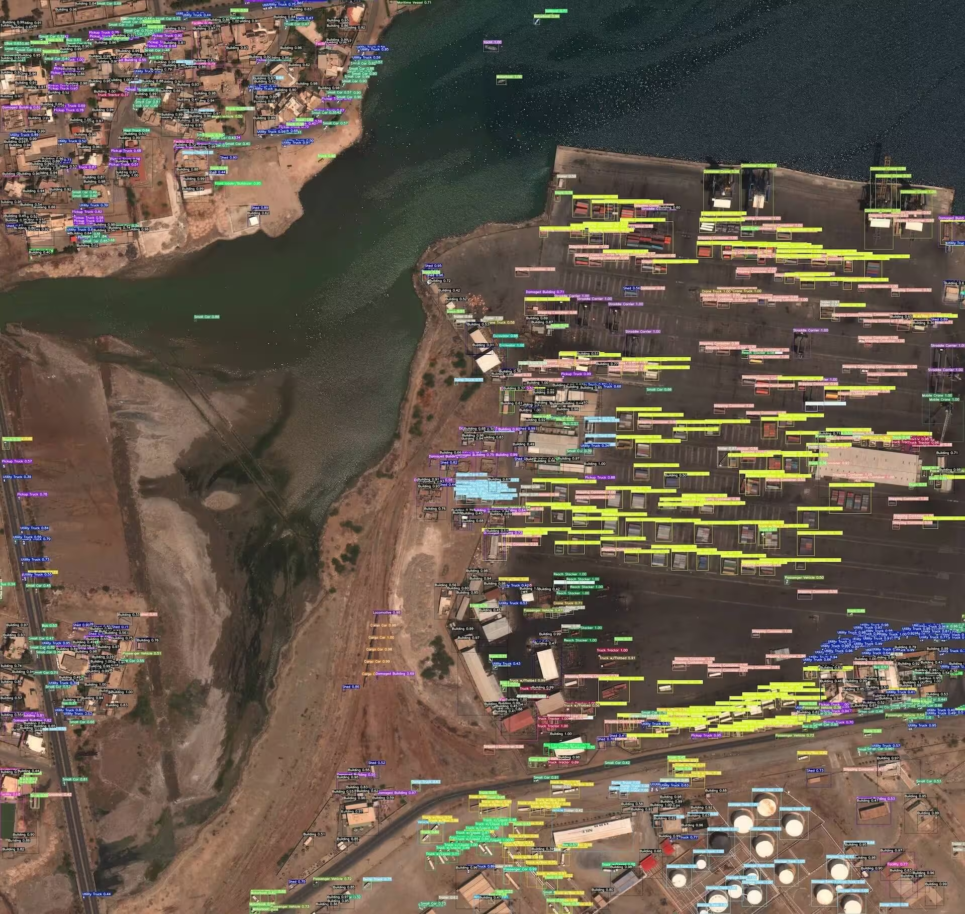
The sample below shows a typical xView scene: high-resolution overhead imagery in which small objects such as vehicles and buildings are annotated with bounding boxes, illustrating why object detection in satellite imagery demands fine-grained localization.
Citations and Acknowledgments#
If you use the xView dataset in your research or development work, please cite the following paper:
@misc{lam2018xview,
      title={xView: Objects in Context in Overhead Imagery},
      author={Darius Lam and Richard Kuzma and Kevin McGee and Samuel Dooley and Michael Laielli and Matthew Klaric and Yaroslav Bulatov and Brendan McCord},
      year={2018},
      eprint={1802.07856},
      archivePrefix={arXiv},
      primaryClass={cs.CV}
}
We would like to acknowledge the Defense Innovation Unit (DIU) and the creators of the xView dataset for their valuable contribution to the computer vision research community. For more information, visit the xView dataset website.
FAQ#
The xView dataset is a satellite-imagery benchmark released for the DIUx xView 2018 Challenge by the U.S. National Geospatial-Intelligence Agency, providing over 1 million object instances across 60 fine-grained classes in 0.3 m WorldView-3 imagery. It supports research on detecting small, rare, and fine-grained objects in overhead views, which are far harder targets than those in ground-level photos.
xView requires a manual download: register at the DIUx xView 2018 Challenge website, download
train_images.zip(~15 GB),train_labels.zip, andval_images.zip(~5 GB) — about 20.7 GB in total — and extract them underdatasets/xView/following the layout shown in the warning at the top of this page. On the first training run, Ultralytics automatically converts the GeoJSON annotations to YOLO format and creates the train/validation split.xView contains 847 labeled training images and 282 validation images without public labels, all captured by WorldView-3 satellites at 0.3 m resolution. Annotations cover over 1 million object instances across 60 classes. Because only the training labels are public, the Ultralytics
xView.yamlconfiguration splits the 847 labeled images roughly 90/10 into training and validation sets; see Dataset Structure for details.Train a YOLO26n model on xView for 100 epochs at an image size of 640:
Train Examplefrom ultralytics import YOLO # Load a model model = YOLO("yolo26n.pt") # load a pretrained model (recommended for training) # Train the model results = model.train(data="xView.yaml", epochs=100, imgsz=640)For detailed arguments and settings, refer to the model Training page.
Cite the paper "xView: Objects in Context in Overhead Imagery" (Lam et al., arXiv:1802.07856, 2018); the full BibTeX entry is in the Citations and Acknowledgments section above.